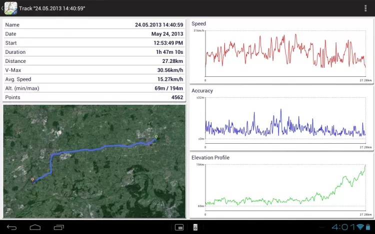
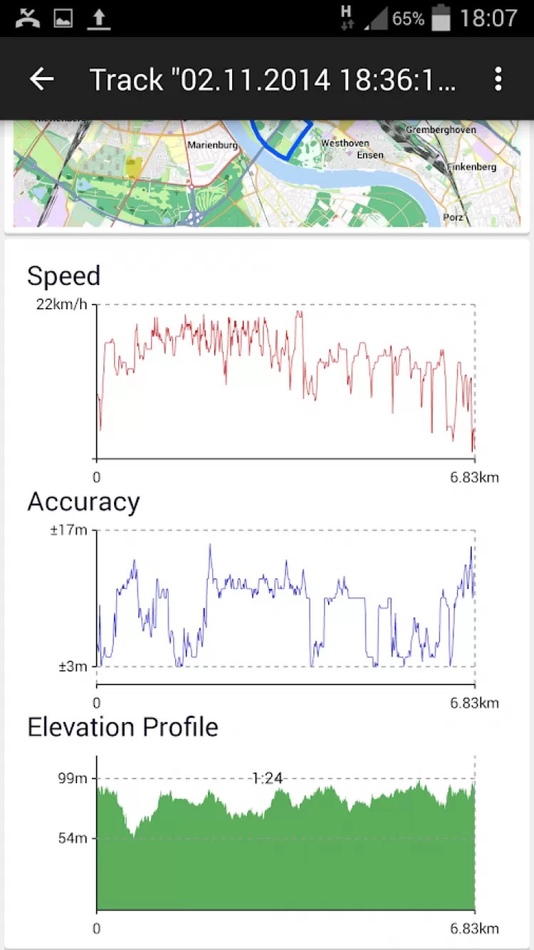
Topographic maps. Breakdown and nomenclature. Topographic maps, measurements and plotting on them Map of 200,000 scale
The concept of nomenclature in topography is completely different from its other meanings in our everyday life. This is a set or list of names, terms used in any branch of science, technology, art, etc., this is a circle of officials appointed by a higher authority. The semantic concept of nomenclature in topography is based on the fact that the adopted provisions should provide an unambiguous designation of topographic sheets or any other maps of various scales.
Nomenclature
Is a designation system for map sheets of different scales.
Breakdown
- the system of dividing the Earth's surface by meridians and parallels. Each sheet is framed.
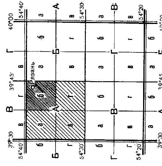
The basis for dividing maps into sheets in our country is international marking maps of scale 1: 1,000,000 (Fig. 5.1).
Fig. 5.1. Breakdown and nomenclature
topographic maps of scale 1: 1,000,000.
The division into rows (belts) by parallels is made from the equator every 4º latitude. The rows are designated by letters of the Latin alphabet: A, B, C, D, E, F, G, H, I, J, K, L, M, N, O, P, Q, R, S, T, U, V, W. Columns within their boundaries coincide with 6º Gaussian projection zones, but their numbering is carried out from the meridian ± 180º to the east. Thus, the column number differs from the zone number by 30 units in one direction or another. Columns are designated (by numbers) Arabic numerals.

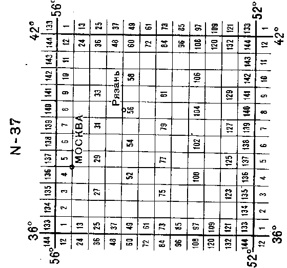
Fig. 5.2. Layout and nomenclature of topographic
maps of the CIS countries at a scale of 1: 1,000,000.
Suppose that the number of the column in the international division is indicated by the number 47. Then the number of the corresponding Gaussian zone will be 47 - 30 = 17. If the number of the column is less than 30, then add 30 to the number of the column to determine the number of the zone. The nomenclature of a sheet of a topographic map at a scale of 1: 1,000,000 is composed of the Latin letter of the row and the Arabic numeral of the column number . for example, S-47. For maps of the southern hemisphere, after the nomenclature in brackets indicate (Yu.P.).
Splitting map sheets at a scale of 1: 500,000 is made by dividing the middle meridian and the middle parallel of the sheet of the map at a scale of 1: 1,000,000 into four parts, which are designated by capital letters of the Russian (Ukrainian) alphabet. Nomenclature of map sheets at a scale of 1: 500,000 consists of the nomenclature of a sheet of a 1: 1,000,000 scale map, of which it is a part, and the corresponding letter.
Partitioning of sheets of maps of scales 1: 200,000 and 1:100 000 is produced by dividing each sheet of the map at a scale of 1: 1,000,000 by meridians and parallels, respectively, into 36 and 144 parts (Fig. 5.3). Sheets of maps of a scale of 1: 200,000 are numbered in Roman numerals, and at a scale of 1: 100,000 - in Arabic numerals in rows from west to east. The nomenclature of sheets of maps of the indicated scales consists of the nomenclature of the corresponding millionth sheet and its own number, which for sheets of maps of scales 1: 200,000 and 1: 100,000 is indicated to the right of the nomenclature of the millionth sheet.

Fig. 5.3. Layout and nomenclature of sheets of maps at a scale of 1: 500,000,
1: 200,000, 1: 100,000 in a map sheet at a scale of 1: 1,000,000
Sheets of a map of scale 1: 50,000 obtained by dividing the sheets of a 1: 100,000 scale map into four parts (Fig. 5.4), denoted by capital letters of the Russian (Ukrainian) alphabet. The dimensions of the leaf are 10 ′ in latitude and 15 ′ in longitude.

The nomenclature of these sheets is formed by attaching the corresponding letter to the nomenclature of a sheet of 1: 100,000 scale, for example, N-37-4-A. (fig. 5.4)
Sheets of a map scale 1: 25,000 are obtained by dividing map sheets at a scale of 1: 50,000 into four parts (Fig. 5.4), each of which is denoted by lowercase letters of the Russian alphabet. The dimensions of these sheets are 5 ′ in latitude, 7′30 ″ in longitude, and the nomenclature is supplemented with the corresponding letter: N-37-4-В-в.
Map sheet of 1:25 000 scale is divided into four map sheets scale 1:10 000, each of which has dimensions in latitude 2'30 ″, in longitude 3′45 ″. They are denoted by Arabic numerals, which are indicated after the nomenclature of a sheet of a map of a scale of 1:25 000, of which they are a part, for example, N-37-134-B-v-2.
Splitting map sheets at a scale of 1: 5,000 produced by dividing the map sheets at a scale of 1: 100,000 into 256 parts (16 rows in latitude and longitude). Sheets are numbered in Arabic numerals in rows from west to east. The size of each leaf is 1'15 "in latitude and 1'53.5" in longitude. The nomenclature of these sheets is formed by attaching the corresponding number in brackets to the nomenclature of a map sheet at a scale of 1: 100,000, for example: N-37-134- (16).

Fig. 5.5. Splitting map sheets at a scale of 1: 5,000
Map sheets of scale 1: 2,000 obtained by dividing the sheets of a 1: 5,000 scale map into nine parts and denoted by lowercase letters of the Russian alphabet, for example, N-37-134- (16-f). The size of each sheet is 25 ″ in latitude and 37.5 ″ in longitude.
Large-scale topographic surveys in areas less than 20 km2 are carried out in private rectangular coordinate systems,
not related to the geographic system. In these cases, the layout of the plan sheets is made not by meridians and parallels, but by the lines of the coordinate grid. The sheets are in the form of squares with dimensions of 40 × 40 cm for plans at a scale of 1: 5000 and 50 × 50 cm for plans at scales of 1: 2000 - 1: 500. The layout is based on a 1: 5,000 scale plan sheet, denoted by Arabic numerals.
To a sheet of a plan of a scale of 1: 5000 there are 4 sheets in scale 1: 2,000
, denoted by capital letters of the Russian alphabet (Fig. 5.6) ,.
Plan sheet at a scale of 1: 2000 is divided into 4 plan sheets scale 1: 1000
, denoted by Roman numerals, or 16 sheets of plans scale 1: 500
, denoted by Arabic numerals (Fig. 5.6).

Fig. 5.6 .
Layout and nomenclature of sheets of maps of scales 1: 2000, 1: 1000, 1: 500
In fig. 5.7 shows the general scheme of the layout and nomenclature of topographic maps, adopted in Ukraine.
Other systems of designation of large-scale plans are also possible when performing surveys of various objects. In these cases, the accepted schemes of their layout and numbering are indicated outside the framework of the sheets of plans.

Fig. 5.7 .
General scheme of layout and nomenclature of topographic maps, adopted in Ukraine.
Due to the fact that when moving to the north or south pole, the parts projected onto the plane the earth's surface decrease in longitude, the sheets of topographic maps become narrow and inconvenient for practical use. Sheets of topographic maps for latitudes 60º - 76º are published doubled in longitude, and for latitudes 76º - 88º - quadrupled in longitude. For the Arctic and Antarctic regions located at latitudes from 88º to 90º, large-scale maps are published in azimuthal projection.
5.2. DETERMINATION OF THE GEOGRAPHICAL COORDINATES OF THE ANGLES OF THE FRAME OF THE TOPOGRAPHIC MAP SHEET
The system of marking and nomenclature of map sheets makes it possible to determine the geographic coordinates of the corners of the frame of any sheet of topographic maps of the entire scale series, as well as to find the nomenclature of a map sheet of any scale on which this point is located by the geographic coordinates of a point.
South latitude
the frame of the map sheet at a scale of 1: 1,000,000 can be determined using Table 5.1.
Numbers and designations of the northern hemisphere belts
Table 5.1
If there is no belt designation table, then first determine the serial number of the Latin letter of the belt (serial number 1 corresponds to the Latin letter A, 2 - B, 3 - C, ...). Then the belt number is multiplied by 4 and the geographic sprat value is obtained. φ
north parallel of the leaf. By decreasing this value by 4. get the latitude of the southern parallel of the leaf frame.
To determine the longitudes of the meridians that bound the sheet, it should be borne in mind that the Greenwich meridian is taken as the beginning of the longitude count, and the beginning of the column count goes from the meridian, which has a longitude of 180. Therefore, for columns with numbers 31-60 (east of the Greenwich meridian), the column number is reduced by 30, multiplied by 6º and the value is determined geographic longitude
east meridian
sheet. By decreasing this value by 6º, the value of the longitude of the western meridian of the leaf is obtained.
Example... For a sheet of a map of scale 1: 1,000,000 with the N-37 nomenclature, determine the geographical coordinates (Fig. 5.8).
Decision:
- the ordinal number of the letter N in the Latin alphabet 14;
- by the ordinal number we determine the latitude of the northern parallel 14 × 4 = 56º
- reducing the value of the northern latitude by 4, we obtain the latitude of the southern parallel of the sheet frame 56º - 4º = 52º
- we determine the longitude of the eastern meridian (37 - 30) × 6º = 42º
- decreasing the value of the longitude of the eastern meridian by 6, we obtain the value of the longitude of the western meridian 42º - 6º = 36º

Fig. 5.8. Geographic coordinates of the corners of the frame
1: 1 000 000 scale map sheet with N-37 nomenclature
5.3. DETERMINATION OF THE NOMENCLATURE OF MAP SHEETS BY GEOGRAPHICAL COORDINATES OF OBJECTS
By the geographic coordinates of a point, you can determine the nomenclature of any sheet of a topographic map on which this point is located
This requires:
- determine the number of the belt in which the required sheet is located, dividing the latitude in degrees plus four by 4.
Attention! To obtain an integer number of degrees in the remainder, division should be performed without using a calculator.
- According to the belt number from Table 5.1, determine belt designation (latin letter).
The Latin letter of the belt can be calculated using a computer. To do this, in Microsoft Excel spreadsheets, enter the formula:
= SYMBOL ( belt number+64)
- determine the column number by dividing the longitude in degrees plus six by 6 and add 30 to the quotient;
- by the remainder (degrees and minutes), determine the nomenclature of sheets of maps of a larger scale.
Example.
Object coordinates: latitude 53 ° 50'N .; longitude 40 ° 30′E
Determine the nomenclature of a sheet of a map with a scale of 1: 500,000.
Decision.
Belt number (row)
(53 + 4): 4 = 14 integers.
We will use 1º in the remainder of division and 50 ′ latitude (the total remainder is 1 ° 50 ′) to determine the nomenclature of a sheet of a map of a larger scale.
14 whole is the serial number of the row. Number 14 corresponds to the Latin letter N. Symbol N corresponds to the belt of the map at a scale of 1: 1,000,000.
Column number
(40 + 6) : 6 + 30 = 37.
The remainder in longitude is 4 ° + 30 "= 4 ° 30".
The nomenclature of a sheet of a map at a scale of 1: 1,000,000 will be N - 37.
We draw up a scheme for dividing the sheet 1: 1,000,000 into equal parts in longitude and latitude (Fig. 5.9).

Figure 5.9. Determination of the nomenclature of the map sheet 1: 500 000
We count from the southern border of the scheme 1 ° 50 '(latitude remainder) and from the western border 4 ° 30' (longitude remainder). We get the intersection of the lines at the quarter, indicated by the capital letter G. Thus, the sought nomenclature of a sheet of a map at a scale of 1: 500,000 will be N-37-G.
To determine the nomenclature of maps at a scale of 1: 200,000, the method for determining the trapezoid number is the same as for a scale of 1: 500,000.

Figure 5.10. Determination of the nomenclature of the map sheet 1: 200,000
At the intersection of the dotted lines (Figure 5.10) we see the Roman numeral XXIII. We add a Roman numeral to the nomenclature of sheet 1: 1,000,000 and we obtain the nomenclature of a sheet of a map of scale 1: 200,000 N-37-XXIII.
By sequentially drawing up the scheme of dividing sheets with the designation of their coordinates, you can determine the nomenclature of sheets for maps of a larger scale.
5.4. DEFINITION OF NOMENCLATURE OF ADJACENT MAP SHEETS
To select the required map sheets, there are prefabricated tables - schematic maps of a small scale, which show the layout and nomenclature of maps. To select a sheet on a prefab table of the appropriate scale, a given route or area is applied and, according to the layout indicated on the prefab table, the nomenclature of sheets included in the intended area is written out.

Fig. 5.11. Fragment of the prefabricated table of sheets
maps of scale 1: 100,000
In the absence of a prefab table, the nomenclature of map sheets is determined using the layout schemes made independently. In this case, two cases are possible. If the nomenclature of one or several sheets is known and it is required to determine the nomenclature of a number of adjacent sheets, then a scheme for plotting maps of the appropriate scale is performed, these sheets are marked on it and the nomenclature of adjacent sheets is written out.
If you have to determine the nomenclature of map sheets for a new area, then you need to geographic map determine the geographic coordinates of the object located in the desired area, by them find its position on the layout diagram of the map sheets at a scale of 1: 1,000,000 and write out the nomenclature of this sheet. Then, according to the scheme of cutting sheets of a map of the appropriate scale, taking into account the latitude and longitude of the corners of a sheet of a map of a scale of 1: 1,000,000, the position of the object is found by its geographic coordinates and the nomenclature of the required sheets is written out.

Fig. 5.12. Labels on the sides of the nomenclature frame of adjacent map sheets
The nomenclature of sheets adjacent to the existing map sheet can be recognized by the captions on the frame on the corresponding side (Fig. 5.12).
Examples of drawing up diagrams of adjacent map sheets are shown in Fig. 5.13, and 5.14.

Fig. 5.13. Scheme of adjacent map sheets at a scale of 1: 100,000.
Fill highlighted adjacent sheets.

Fig. 5.14 Scheme of adjacent sheets of a map with a scale of 1: 200,000. Fill marks adjacent sheets.
5.5. DIGITAL CARD NOMENCLATURE
The digital nomenclature of cards is used to record cards and draw up applications for cards using a computer. Each letter denoting a belt has been replaced with two-digit numbers. These numbers correspond to the ordinal number of the belt (or letters in the Latin alphabet). For example, A-01, B-02, C-03, D-04, E-05, F-06,
The digital nomenclature of the map sheet at a scale of 1: 1,000,000 K-38 will be written 11-38.
Each sheet of a map of scale 1: 200,000 is denoted by a two-digit number from 01 to 36, and a scale of 1: 100,000 - by three numbers from 001 to 144. Letters in the nomenclature of sheets of maps of scales 1: 500,000, 1: 50,000 and 1: 25,000 are replaced by the numbers 1, 2, 3, 4, respectively.
The digital form of recording nomenclatures for all scales is given in table. 5.2.
Table 5.2.
To the nomenclature of maps of the Southern Hemisphere, letters UP are added to the usual nomenclature in brackets, for example M-Z6-A (UP). Before the digital nomenclature of sheets of maps of the Southern Hemisphere, they put a number: 9, for example, M-36-A (UP) has the form 9-13-36-1.
5.6. METHODOLOGY OF SELECTING CARDS BY ASSOCIATED TABLES
The selection of the necessary sheets of maps for the point of the terrain specified by the coordinates is carried out according to the precast tables.
Prefabricated tables represent a blank version of a small-scale map, on which the layout and nomenclature of maps are indicated. For the convenience of choosing maps, rivers, lakes, settlements, borders and other terrain objects are applied to the prefab tables.
To select the necessary map sheets for a given point of the terrain, it is necessary to put this point on the collection table by coordinates and write out the nomenclature of maps of the required scale.
To select maps for a given area, it is necessary to plot the boundaries of the area on the collection table, and then write out the nomenclature of the required map scales.
When gluing sheets of cards into a block, it is necessary to know the nomenclature of sheets adjacent to each other. To do this, use the layout of the sheets, which is placed under the southern frame of the map. On large-scale maps, the layout of sheets is not printed, and the nomenclature of adjacent sheets is indicated on each side of the map frame.
The known coordinates of the point can be used to determine the nomenclature of the map sheet. To do this, you first need to define the nomenclature of the scale map sheet
1: 1 000 000. The belt of the desired sheet is determined by dividing the latitude of the point in degrees by 4. The column number is determined by dividing the longitude of the point in degrees by 6. 30 is added to the resulting number. the big side. Having received the nomenclature of a sheet of a map with a scale of 1: 1,000,000, you can easily determine the nomenclature of a sheet of a map of any scale.
Example. The geographical coordinates of the object are given: latitude 56 ° 20 ′,
longitude 70 ° 30 ". Determine the nomenclature of a sheet of march on a scale of 1: 1 000 000.
Decision.
1. Determine the number of the belt: 56 °: 4 = 14, the remainder is 20 ". Round up to an integer, then the ordinal number of the belt will be 15, which corresponds to the letter O of the Latin alphabet.
2. Determine the column number: 70 °: 6 = 11, the remainder is 4 ° 30 ", that is, the required column will be 12 + 30 = 42.
The nomenclature of a sheet of a map of scale 1: 1 000 000 will be O-4
Questions and tasks for self-control
- Give definitions: "card layout", "card nomenclature".
- How is the plotting done and what symbols are used to compose the nomenclature of maps of scales: 1: 1,000,000, 1: 100,000, 1:50,000, 1:25,000, 1:10,000, 1: 5,000, 1: 2,000?
- How is the plotting performed and what symbols are used to compose the nomenclature of scale plans: 1: 5,000, 1: 2,000, 1: 1,000, 1: 500?
- How to determine the nomenclature of a sheet of a map at a scale of 1: 500,000, if the geographical latitude and longitude of a point (object) are known?
- How to find the nomenclature of adjacent and adjoining (corner) sheets according to the nomenclature of a sheet of a 1: 200,000 scale map?
- What is digital card nomenclature?
- What is the difference between the nomenclature of maps of the southern hemisphere and the nomenclature of maps of the northern hemisphere?
- What are precast tables?
- How is the selection of maps for a given area according to precast tables carried out?
A topographic map is a multipurpose geographic map that shows the terrain in detail. The topographic map contains information about geodetic control points, relief, hydrography, vegetation, soils, economic and cultural objects, roads, communications, borders and other terrain objects. The completeness and accuracy of topographic maps allow us to solve technical problems.
The science of making topographic maps is topography.
All geographical maps, depending on the scale, are conventionally divided into the following types:
- topographic plans - up to 1: 5,000 inclusive;
- large-scale topographic maps - from 1:10 000 to 1: 200 000 inclusive;
- medium-scale topographic maps - from 1: 200,000 (not including) to 1: 1,000,000 inclusive;
- small-scale topographic maps - less (less) 1: 1,000,000.
The smaller the denominator numerical scale, the larger the scale. Plans are made on a large scale, and maps on a small scale. The maps take into account the "sphericity" of the Earth, but the plans do not. Because of this, plans should not be drawn up for areas over 400 km² (that is, land plots larger than 20 × 20 km). The main difference between topographic maps (in a narrow, strict sense) is their large scale, namely, a scale of 1: 200,000 and larger (the first two points, more strictly - the second point: from 1:10,000 to 1: 200,000 inclusive).
The most detailed geographical objects and their outlines are depicted on large-scale (topographic) maps. When you zoom out on a map, details have to be eliminated and generalized. Individual objects are replaced by their collective values. The selection and generalization becomes obvious when comparing a multi-scale image of a settlement, which is given in the form of individual buildings on a scale of 1:10 000, blocks on a scale of 1:50 000, and a punson on a scale of 1: 100 000. The selection and generalization of content when making geographic maps is called cartographic generalization. It aims to preserve and highlight on the map the typical features of the depicted phenomena in accordance with the purpose of the map.
Secrecy
Topographic maps the territory of Russia up to a scale of 1: 50,000 inclusive are secret, topographic maps of a scale of 1: 100,000 are intended for official use (DSP), smaller than a scale of 1: 100,000 are unclassified.
Those working with maps up to a scale of 1: 50,000 must, in addition to a permit (license) from the Federal Service for State Registration, Cadastre and Cartography, or a certificate of a self-regulatory organization (SRO), obtain permission from the FSB, since such maps constitute a state secret. For the loss of a map with a scale of 1: 50,000 and larger, in accordance with Article 284 of the Criminal Code of the Russian Federation "Loss of documents containing state secrets" punishment is provided for up to three years in prison.
At the same time, after 1991 secret maps throughout the USSR, stored in the headquarters of military districts located outside of Russia, appeared on the free market. Since the leadership of, for example, Ukraine or Belarus does not need to maintain the secrecy of maps of foreign territories.
The problem of existing secrecy on maps became acute in February 2005 in connection with the launch of the Google Maps project, which allows anyone to use high-resolution color space images (up to several meters), although in Russia any space image with a resolution of more than 10 meters is considered secret and requires an order in the FSB declassification procedures.
In other countries, this problem is resolved by the fact that not areal, but object secrecy is applied. With object secrecy, the free distribution of large-scale topographic maps and images of strictly defined objects, for example, areas of military operations, military bases and training grounds, and anchorages of warships, is prohibited. For this, a technique has been developed for creating topographic maps and plans of any scale that do not have a secrecy stamp and are intended for open use.
Scope of topographic maps and plans
Map scale is the ratio of the length of the line segment on the map to its actual length on the ground.
Scale(from German - measure and Stab - stick) - the ratio of the length of a segment on a map, plan, aerial or satellite image to its actual length on the ground.
Numerical scale- scale, expressed as a fraction, where the numerator is one, and the denominator is a number that shows how many times the image is reduced.
Named (verbal) scale- type of scale, verbal indication of what distance on the ground corresponds to 1 cm on the map, plan, photograph.
Linear scale- an auxiliary measuring ruler applied to the maps to facilitate the measurement of distances.
A named scale is expressed by named numbers that indicate the lengths of mutually corresponding segments on the map and in nature.
For example, 1 centimeter is 5 kilometers (1 cm is 5 km).
Numerical scale is a scale expressed as a fraction, in which: the numerator is equal to one, and the denominator is equal to a number that shows how many times the linear dimensions on the map are reduced.
The scale of the plan is the same at all points.
The scale of the map at each point has its own particular value, depending on the latitude and longitude of this point. Therefore, its strict numerical characteristic is a particular scale - the ratio of the length of an infinitely small segment D / on the map to the length of the corresponding infinitesimal segment on the surface of the ellipsoid of the globe. However, in practical measurements on the map, its main scale is used.
Scale Expression Forms
Scale designation on maps and plans has three forms: numerical, named and linear scales.
The numerical scale is expressed as a fraction, in which the numerator is a unit, and the denominator M is a number showing how many times the dimensions on the map or plan are reduced (1: M)
In Russia, standard numerical scales are adopted for topographic maps:
For special purposes, topographic maps are also created at scales of 1: 5,000 and 1: 2,000.
The main scales topographic plans in Russia are:
1: 5000, 1: 2000, 1: 1000 and 1: 500.
However, in land management practice, land use plans are most often drawn up on a scale of 1: 10,000 and 1: 25,000, and sometimes 1: 50,000.
When comparing various numerical scales, the smaller is the one with the larger denominator M, and, conversely, the smaller the denominator M, the larger the scale of the plan or map.
So, a scale of 1: 10,000 is larger than a scale of 1: 100,000, and a scale of 1: 50,000 is smaller than a scale of 1: 10,000.
Named scale
Since the lengths of lines on the ground are usually measured in meters, and on maps and plans - in centimeters, it is convenient to express the scales in verbal form, for example:
One centimeter is 50 meters. This corresponds to a numerical scale of 1: 5000. Since 1 meter is equal to 100 centimeters, the number of meters of terrain contained in 1 cm of a map or plan can be easily determined by dividing the denominator of the numerical scale by 100.
Linear scale
It is a graph in the form of a straight line segment, divided into equal parts with the signed values of the lengths of the terrain lines commensurate with them. The linear scale allows you to measure or plot distances on maps and plans without calculations.
Scale accuracy
The limiting possibility of measuring and plotting segments on maps and plans is limited to 0.01 cm. The corresponding number of meters of terrain on a map or plan scale is the ultimate graphic accuracy of a given scale. Since the accuracy of the scale expresses the length of the horizontal distance of the terrain line in meters, then to determine it, the denominator of the numerical scale should be divided by 10,000 (1 m contains 10,000 segments of 0.01 cm). So, for a map with a scale of 1: 25,000, the scale accuracy is 2.5 m; for map 1: 100,000 - 10 m, etc.
Scales of topographic maps
Below are the numerical scales of the maps and the corresponding named scales:
- Scale 1: 100,000
1 mm on the map - 100 m (0.1 km) on the ground
1 cm on the map - 1000 m (1 km) on the ground
10 cm on the map - 10,000 m (10 km) on the ground
- Scale 1: 10000
1 mm on the map - 10 m (0.01 km) on the ground
1 cm on the map - 100 m (0.1 km) on the ground
10 cm on the map - 1000m (1 km) on the ground
- Scale 1: 5000
1 mm on the map - 5 m (0.005 km) on the ground
1 cm on the map - 50 m (0.05 km) on the ground
10 cm on the map - 500 m (0.5 km) on the ground
- Scale 1: 2000
1 mm on the map - 2 m (0.002 km) on the ground
1 cm on the map - 20 m (0.02 km) on the ground
10 cm on the map - 200 m (0.2 km) on the ground
- Scale 1: 1000
1 mm on the map - 100 cm (1 m) on the ground
1 cm on the map - 1000 cm (10 m) on the ground
10 cm on the map - 100 m on the ground
- Scale 1: 500
1 mm on the map - 50 cm (0.5 meters) on the ground
1 cm on the map - 5 m on the ground
10 cm on the map - 50 m on the ground
- Scale 1: 200
1 mm on the map - 0.2 m (20 cm) on the ground
1 cm on the map - 2 m (200 cm) on the ground
10 cm on the map - 20 m (0.2 km) on the ground
- Scale 1: 100
1 mm on the map - 0.1 m (10 cm) on the ground
1 cm on the map - 1 m (100 cm) on the ground
10 cm on the map - 10m (0.01 km) on the ground
To convert a numerical scale to a named scale, it is necessary to convert the number in the denominator and corresponding to the number of centimeters into kilometers (meters). For example, 1: 100,000 in 1 cm - 1 km.
To convert a named scale to a numerical one, you need to convert the number of kilometers to centimeters. For example, in 1 cm - 50 km 1: 5,000,000.
Nomenclature of topographic plans and maps
Nomenclature is a system of marking and designating topographic plans and maps.
The division of a multi-sheet map into separate sheets according to a certain system is called a map layout, and the designation of a sheet of a multi-sheet map is called a nomenclature. In cartographic practice, the following systems of drawing maps are used:
- along the lines of the cartographic grid of meridians and parallels;
- along the lines of a rectangular grid;
- along auxiliary lines parallel to the middle meridian of the map and a line perpendicular to it, etc.
The most widespread in cartography is the distribution of maps along the lines of meridians and parallels, since in this case the position of each sheet of the map on the earth's surface is precisely determined by the values of the geographical coordinates of the corners of the frame and the position of its lines. Such a system is universal, convenient for depicting any territories of the Earth, except for the polar regions. It is used in Russia, USA, France, Germany and many other countries of the world.
The nomenclature of maps on the territory of the Russian Federation is based on the international layout of map sheets at a scale of 1: 1 000 000. To obtain one sheet of a map of this scale, the globe is divided by meridians and parallels into columns and rows (belts).
Meridians are drawn every 6 °. The number of columns from 1 to 60 goes from 180 ° meridian from 1 to 60 from west to east, counterclockwise. The columns coincide with the rectangular zones, but their numbers differ by exactly 30. So for zone 12, the column number is 42.
Column numbers
Parallels are drawn every 4 °. The belts from A to W are counted from the equator to the north and south.
Row numbers
Map sheet 1: 1,000,000 contains 4 sheets of map 1: 500,000, designated by capital letters A, B, C, D; 36 sheets of map 1: 200,000, designated from I to XXXVI; 144 sheets of 1: 100,000 map, denoted from 1 to 144.
Map sheet 1: 100,000 contains 4 map sheets 1: 50,000, which are designated by capital letters A, B, C, D.
Map sheet 1: 50,000 is divided into 4 map sheets 1: 25,000, which are denoted by lowercase letters a, b, c, d.
Within the 1: 1 000 000 map sheet, the arrangement of numbers and letters for the designation of map sheets 1: 500 000 and larger is made from left to right in rows and in the direction to the South Pole. The initial row is adjacent to the northern border of the sheet.
The disadvantage of this layout system is the change in the linear dimensions of the northern and southern borders of the map sheets, depending on the geographic latitude. As a result, as the distance from the equator increases, the sheets take on the form of increasingly narrow stripes elongated along the meridians. Therefore, topographic maps of Russia of all scales from 60 to 76 ° north and south latitudes are published doubled in longitude, and in the range from 76 to 84 ° - quadruple (on a scale of 1: 200,000 - tripled) in longitude sheets.
The nomenclatures of sheets for maps of scales 1: 500,000, 1: 200,000 and 1: 100,000 are composed from the nomenclature of a sheet of a 1: 1,000,000 map with the subsequent addition of designations of sheets of maps of the corresponding scales. The nomenclatures of double, triple or quadruple sheets contain the designations of all individual sheets are presented in the table:
Nomenclatures of sheets of topographic maps for the northern hemisphere.
| 1:1 000 000 | N-37 | P-47.48 | T-45.46.47.48 |
|---|---|---|---|
| 1:500 000 | N-37-B | R-47-A, B | T-45-A, B, 46-A, B |
| 1:200 000 | N-37-IV | P-47-I, II | T-47-I, II, III |
| 1:100 000 | N-37-12 | P-47-9.10 | T-47-133, 134,135,136 |
| 1:50 000 | N-37-12-A | P-47-9-A, B | T-47-133-A, B, 134-A.B |
| 1:25 000 | N-37-12-A-a | R-47-9-A-a, b | T-47-12-A-a, b, B-a, b |
On the sheets of the southern hemisphere to the right of the nomenclature, a signature (UP) is placed.
N37
On the sheets of topographic maps of the entire scale series, along with the nomenclature maps, their code digital designations (ciphers) are placed, which are necessary for accounting maps using automated means. The coding of the nomenclature consists in replacing letters and Roman numerals in it with Arabic numerals. In this case, the letters are replaced by their ordinal numbers in alphabetical order. The numbers of belts and columns of the map 1: 1,000,000 are always designated with two-digit numbers, for which zero is assigned to the single-digit numbers in front. Map sheet numbers 1: 200,000 within the 1: 1,000,000 map sheet are also denoted by two-digit numbers, and map sheet numbers 1: 100,000 - by three-digit ones (one or two zeros are assigned to the one-digit and two-digit numbers in front, respectively).
Knowing the nomenclature of maps and the system of its construction, it is possible to determine the scale of the map and the geographical coordinates of the corners of the sheet frame, that is, to determine to which part of the earth's surface this map sheet belongs. And, conversely, knowing the scale of the map sheet and the geographic coordinates of the corners of its frame, you can set the nomenclature of this sheet.
To select the necessary sheets of topographic maps for a specific area and quickly determine their nomenclature, there are special precast tables:

Collective tables are schematic blank maps of a small scale, divided by vertical and horizontal lines into cells, each of which corresponds to a certain map sheet of the corresponding scale. The prefab tables indicate the scale, the labels of the meridians and parallels, the designations of the columns and zones of the map 1: 1 000 000, as well as the order of the numbers of sheets of maps of a larger scale within the sheets of the millionth map. Prefabricated tables are used when drawing up applications for required maps, as well as for the geographical accounting of topographic maps in the troops and in warehouses, the preparation of documents on the cartographic security of territories. A strip or area of operations of troops (route of movement, area of exercises, etc.) is applied to the composite table of maps, then the nomenclature of sheets covering the strip (area) is determined. For example, in the application for map sheets 1: 100,000 of the area shaded in the figure, it is written O-36-132, 144, 0-37-121, 133; N-36-12, 24; N "37-1, 2, 13, 14.

A program that includes a set of high quality topographic maps, some of which were created by the Russian General Staff.
Application Soviet military maps includes topographic maps of the world providing continuous 100K-500K worldwide coverage, road maps, terrain and satellite imagery from Google Maps, and a range of open street maps.
Nice feature of the app Soviet military maps for Android is the presence of a large number of roads not shown on other maps. It is also worth noting that Soviet maps have lost their relevance for developed countries, since they were created in the 80s and it is desirable to use them only for the countries of Africa and Asia. In other cases, it is recommended to use google maps and OSM layers.
Download the Soviet military maps app: one of the best off-road navigation apps for your Android.
Security guarantee
On the FreeSoft website you can download the official version of Soviet military maps Free without torrents via a direct link from your own server.
- All files undergo a daily anti-virus check with new signatures!
- FreeSoft is a member of the Kaspersky White List program.
Applications marked with the Kaspersky Trusted logo were added to the "White List" database as free of viruses and malicious codes. We guarantee that you are downloading unmodified copies original files submitted to Kaspersky Lab for testing. You can be sure that your device will have an up-to-date version of Soviet military maps Free without viruses. - We check the links to the authors' sites, nevertheless, before downloading, we strongly recommend that you read the reviews about the Soviet military maps Free application on our website.
Screenshots


1.1. CLASSIFICATION AND PURPOSE OF TOPOGRAPHIC MAPS
Topographic map- reduced, accurate, detailed and visual image of the earth's surface with all its objects, made in a specific cartographic projection.
Classification of topographic maps. Soviet topographic maps are nationwide. They are published on the scale indicated in table. one.
Table 1
Topographic maps of scale 1: 25,000-1: 1,000,000
Map scale (scale value) | Card name | Signature of the scale of maps on combat documents | Approximate dimensions as a sheet of a map at a latitude of 54 °, km | The area covered by the map sheet at latitude 54 °, km |
Twenty-five thousandth | ||||
(in 1 cm 500 m) | Fifty thousandth | |||
(in 1 cm 1 km) | One hundred thousandth, or kilometer | |||
(in 1 cm 2 km) | Two hundred thousandth, or two kilometers | |||
(in 1 cm 5 km) | ||||
(in 1 cm 10 km) | Millionth, or ten-kilometer |
Note: The first number of leaf sizes indicates the extent from north to south; this dimension is constant for any latitude; the second number is the extent from east to west; this size gradually decreases with increasing latitude.
Topographic maps used by the troops are divided into: large-scale (1: 25000, 1: 50000), medium-scale (1: 100000, 1: 200000), small-scale (1: 500000 I 1 000 000).
Appointment of topographic maps. Topographic maps serve as the main source of information about the terrain and are used to study it, determine distances and areas, directional angles, coordinates of various objects and solve other measuring problems. They are widely used in command and control of troops, as well as as a basis for graphic combat documents and special maps. Topographic maps (mainly on a scale of 1: 100000 and 1: 200000) serve as the main means of orientation on the march and in battle.
Topographic map of scale 1:25 000 is intended for a detailed study of the terrain, as well as for the production of accurate measurements and calculations during the construction of engineering structures, forcing water barriers and in other cases.
Topographic maps of scale 1: 50,000 and I: 100,000 are intended for the study and assessment of the terrain by commanders and staffs in the planning and preparation of combat operations, command and control of troops in battle, to determine the coordinates of firing (starting) positions, reconnaissance assets and targets, as well as for measurements and calculations in the design and construction of military engineering structures and objects.
Topographic map of scale 1: 200,000 is intended for studying and assessing the terrain during planning and preparation of combat operations of all types of the Armed Forces of the USSR and combat arms, command and control of troops in an operation (battle) and planning of troop movements.
Topographic maps of scale 1: 500,000 and I: 1,000,000 are intended for studying and assessing the general nature of the terrain in the preparation and conduct of operations, and are also used by aviation as flight charts.
1.2. PROJECTION OF TOPOGRAPHIC MAPS
Map projections- mathematical methods of displaying on the plane of the surface of the globe when compiling maps.
Spherical surfaces do not unfold on a plane without folds and breaks, and for this reason, distortions of lengths, angles, and areas are inevitable on maps. Only in some projections is the equality of angles preserved, but because of this, the lengths and areas are significantly distorted, or the equality of areas is preserved, but the angles and lengths are significantly distorted.
Projection of maps on a scale of 1: 25000-1: 500,000. Topographic maps of the USSR and many foreign countries are created in the transverse-cylindrical projection of Gauss.
The design of the earth's surface on a plane in the Gaussian projection is carried out along the zones elongated from the north pole to the south. The boundaries of the zones are meridians with longitude divisible by 6 ° (60 zones in total). Within each zone, the earth's surface is projected onto a plane by converting the geographic coordinates of points on the earth's surface into rectangular coordinates on a plane.
The lengths of the lines are preserved only along the axial meridian, in other places they are somewhat exaggerated. The greatest relative distortions of lengths occur at the boundaries of zones and within the USSR reach 1/1000, relative distortions of areas - 1/500. Distance distortions are not detected during graphic measurements on topographic maps; they are taken into account only when performing special tasks associated with the use of long ranges.
Angles within a small area are not distorted; the outlines of the contours on the ground and on the map are practically similar. Distortions of any directions on a 1: 100000 map sheet do not exceed 40 ". All map sheets of any scale within one zone can be glued into one block without any folds or gaps.
Projection of a topographic map of scale 1: 1 000 000- a modified polyconic projection, adopted as an international projection for maps with a scale of 1: 1000,000. Its main characteristics: the design of the earth's surface, covered by a map sheet, is performed on a separate plane; parallels are depicted by arcs of circles, and meridians - by straight lines; greatest distortion lengths within the sheet reaches 0.14% distortion of angles - up to 7, distortion of areas - up to 0.08%.
When four sheets of a map with a scale of 1 1000 000 are added, located within latitudes of 40-60 °, an angular gap of about 20-40 occurs and a linear gap - 2-6 mm.(the divergence of the sheets increases towards the poles). No more than 9 sheets are glued into one block without noticeable breaks.
1.3. SYMBOLS AND CARD DESIGN
Symbols of topographic maps- a system of graphic, alphabetic and numerical designations, with the help of which the location of terrain objects is shown on the map, and their qualitative and qualitative characteristics are transmitted.
Symbols depicting the same objects on maps with a scale of 1: 25000-1: 200000 are almost identical in outline and differ only in size.
Symbols are classified as large-scale, off-scale and explanatory.
Scale (contour) conventional symbols consist of a contour (outer outline of an object); depicted by a solid line or dotted line, within which icons, color or shading indicate the nature of the object.
Linear conventional signs (a kind of large-scale conventional signs) are used when depicting linear objects - roads, power lines, borders, etc. The location and outline of the axis of a linear object are accurately depicted on the map, but their width is greatly exaggerated. For example, a conventional highway sign on maps at a scale of 1: 100000 exaggerates its width by 8-10 times.
A reconnaissance map is a regular or blank (one-color) map, on which conditional know kami intelligence data. It is published to inform the troops of the results of decoding aerial photographs (see section 2.4).
1.6. SCHEDULE AND NOMENCLATURE OF CARDS
Chart splitting is a system of dividing cards into separate sheets. Nomenclature of cards - a system of numbering and designation of individual sheets. Each sheet is framed. The sides of the frames of the sheets of topographic maps are parallels and meridians (Table 3).
Table 3
Sizes of sheets of topographic maps
| Map scale | Sizes of map sheets in degree measure | Typical item record | |
| latitude | longitude | ||
| 1:1000 000 | 4 ° | 6 ° | N— 37 |
| 1:500 000 | 2 ° | 3 ° | N— 37-B |
| 1:200 000 | 40" | 1 ° | N— 37 - XVI |
| 1:100000 | 20" | 30" | N- 37—56 |
| 1:50 000 | 10" | 15" | N— 37-56-A |
| 1:25 000 | 5" | 7" 30" | N— 37-56-A-6 |
The nomenclature of topographic maps of the USSR is based on a 1: 1,000,000 scale map.
The nomenclature of the map at a scale of 1: 1,000,000 (Fig. 2). The entire surface of the Earth is divided by parallels into rows (every 4 °), and by meridians into columns (every 6 °); the sides of the formed trapeziums serve as the boundaries of the map sheets at a scale of 1: 1000,000. Rows are denoted by capital Latin letters from BUT before V, starting from the equator to both poles, and the columns in Arabic numerals, starting from the 180 ° meridian from west to east. The nomenclature of a map sheet consists of a row letter and a column number. For example, a sheet with Moscow is denoted N— 37,
Map sheet of scale 1: 500,000 is the fourth part of the map sheet 1: 1000 000 and is designated by the nomenclature of the sheet of the millionth map with the addition of one of the capital letters A, B, C, D of the Russian alphabet, denoting the corresponding quarter (Fig. 3). For example, a sheet of a map of scale 1: 500000 with Ryazan has a nomenclature N— 37-B.
 Map sheet of scale 1: 200000 it is formed by dividing the millionth leaf into 36 parts (Fig. 3); its nomenclature consists of the designation of a sheet of a map at a scale of 1: 1000,000 with the addition of one of the Roman numerals 1, II, III, IV,. ... ., XXXVI. For example, a sheet with Ryazan has the nomenclature N— 37 — XVI

Fig. 3. Layout and nomenclature of sheets of maps of scale 1: 500,000 and I: 200,000
Map sheet of scale 1: 100,000 obtained by dividing a sheet of a millionth card into 144 parts (Fig. 4); its nomenclature consists of the designation of a map sheet 1: 1000,000 with the addition of one of the numbers 1, 2, 3, 4, ..., 143, 144. For example, a sheet of one hundred thousandth map from Ryazan will be ^ -37-56.
A map sheet at a scale of 1: 50,000 is formed by dividing a map sheet at a scale of 1: 100000 into four parts (Fig. 5); its nomenclature consists of the nomenclature of the hundred-thousandth card and one of the capital letters A, B, C, D of the Russian alphabet. For example, N — 37— 56-A. A 1: 25000 scale map sheet is obtained by dividing a 1:50 000 scale map sheet into four parts; its nomenclature is formed from the nomenclature of the fifty-thousandth card with the addition of one of lowercase letters a, b, c, d of the Russian alphabet. An example in fig. five N— 37 - 56 - A - b.
 On sheets of maps for the southern hemisphere, a signature in brackets is added to the sheet nomenclature Yu.P .; for example, A-32-B (Yu.P.).
Map sheets located between latitudes 60-76 ° are doubled in longitude; for example, a map sheet with a scale of 1: 1000,000 in longitude will have a length of not 6, but 12 °.
Double sheets of the millionth map are indicated by an indication of a row (letter) and two corresponding columns (an odd and subsequent even number); for example, a sheet of a map of scale 1: 1,000,000 for the region of Murmansk has a nomenclature R— 35,36.
Double sheets of maps of other scales are indicated in a similar way: a letter or number of the eastern sheet is assigned to the nomenclature of the western left sheet, for example R— 35-25.26. Map sheets located north of the 76 ° parallel are issued quadrupled in longitude. Their designation is carried out in the same order as for double sheets, only the numbers of the next three sheets are assigned to the nomenclature of the western sheet.
1.7. SELECTION AND DEMANDING OF CARDS
To select the required map sheets, there are prefabricated tables - schematic maps of a small scale, which show the layout and nomenclature of maps. Collective tables are published in scale and brought to the headquarters and troops in the same way as maps.
For the selection of map sheets, an action band of a unit or an exercise area is applied to the combined table of the appropriate scale, and the nomenclature of the sheets included in the designated area is written out according to the layout indicated on the combined table.
An example of selecting maps at a scale of 1: 100,000 for the area outlined in the table in Fig. 6:
N 35-143, 144; M- 35-11, 12; N 36-133, 134; M —36— 1,2.
In the absence of a prefab table, the nomenclature of map sheets is determined using the layout schemes (see Fig. 2,3,4,5). In this case, two cases are possible.
If the nomenclature of one or several sheets is known and it is required to determine the nomenclature of a number of adjacent sheets, then they take a map plotting scheme of the appropriate scale, mark these sheets on it and write out the nomenclature of adjacent sheets.
If you have to determine the nomenclature of map sheets for a new area, then you need to determine the geographic coordinates of an object located in the desired area using a geographic map, use them to find its position on the layout of map sheets at a scale of 1: 1000,000 (see Fig. 2 ) and write out the nomenclature of this sheet. Then, according to the scheme of cutting sheets of a map of the appropriate scale, taking into account the latitude and longitude of the corners of the sheet of a map with a scale of 1: 1000,000, the position of the object is found by its geographic coordinates and the nomenclature of the required sheets is written out.

Fig. 6. Prefabricated table of map sheets of scale 1: 100000
The nomenclature of sheets adjacent to the existing map sheet can be recognized by the captions on the frame on the corresponding side (Fig. 7).

Fig. 7. Labels on the sides of the nomenclature frame of adjacent map sheets
Claiming cards. The cards are issued on the basis of applications drawn up in accordance with the established form (Table 4).
An application for topographic maps is drawn up according to their scale, starting with the largest one, with a sequential transition to smaller ones. Nomenclatures are written in ascending order, and only new (changing) letters or numbers of the nomenclature are written, as shown in table. 4. The number and year of publication are indicated in the case when maps are already available and it is desirable to receive maps of the same edition. It is mandatory to fill in the "consists" column. Totals are calculated for each scale and for the entire application.
Table 4 Application form for topographic maps
| Scale, nomenclature | Vulture | Number and year of publication | Number of sheets | Note | ||
| includes | required | released | ||||
| 1:100 000 | ||||||
| M- 38 —12 | No neck | 1—1968 | 20 | 40 | ||
| Also | 1—1968 | 20 | 40 | |||
| „ | 2—1970 | 20 | 40 | |||
| , | 2—1970 | 20 | 40 | |||
| Total. ... ... | — | — | 80 | 160 | ||
1.8. PREPARING THE CARD FOR WORK
Preparing the map for work includes: evaluating the map, gluing the map sheets, folding the map and lifting the terrain elements on the map.
Card rating- familiarization with the map and understanding of its features. Acquaintance with the map is carried out on the following issues: scale, height of relief section, year of survey (compilation), number and year of publication, direction correction.
The scale is recognized by the signature at the bottom of the map sheet and the size of the side of the square of the coordinate grid in kilometers and the magnitude of the scale (how many meters or kilometers corresponds to 1 cm on the map). In addition, they understand the accuracy, completeness and detail of the map.
The height of the relief section is recognized by the signature under the map scale and they understand the completeness and detail of the relief image, as well as what steepness of the slope corresponds to the distance between the contours of 1 mm.
The year of shooting or drawing up a map from the source materials is recognized by the signature in the southeastern corner of the sheet, while understanding the modernity of the map and possible changes in the area.
The number and year of publication are signed under the nomenclature of the sheet of the map (on the maps of the old edition in the north-western corner of the sheet). The number and year of publication are indicated in combat documents in order to ensure the unity of orientation and target designation.
The direction correction is determined by reference text or a diagram placed in the southwest corner of the sheet. The direction correction is clarified if you have to work with a map on the ground or move in azimuths.
 Bonding a card(fig. 8). Before gluing, the map sheets are laid out in the appropriate order. To speed up the layout of a large number of sheets, it is recommended to draw up a diagram of their arrangement or use a composite table, outlining the sheets to be glued on it. After that, they begin to trim the edges of the adjoining sheets; cut off the eastern edges (except for the sheets of the extreme right column) and southern (except for the bottom row). Trimming is done with a sharp knife (razor blade) or cutters exactly along the inner frame of the sheet. Cutting cards with a knife is usually done without a ruler on a cardboard backing. The blade of the knife (razor) should be kept at an acute angle (inclined in the direction of the cutting line).
First, the sheets are glued in rows or columns in the direction where the strip is shorter, then the rows or columns are glued together. Gluing of sheets in columns starts from the bottom, and in rows - to the right.
When gluing the cards, put the cut sheet back on the adjacent uncut sheet and, bringing them together along the gluing line, apply a thin uniform layer of glue with a brush to the gluing strip. Then, turning the top sheet over, they combine the frames of the sheets, kilometer lines and the corresponding contours. The place of gluing is wiped with a dry cloth (paper), making a movement across the gluing line towards the edge. Slight misalignment can be corrected by wiping in the opposite direction of the offset. The gluing of rows or columns is performed in the same order.
When gluing long strips (rows or columns), it is recommended to roll the strip with cut sheets into a roll, and apply glue to the lower strip (with cut edges) and, gradually unwinding the roll, align and iron the strips to be glued.
In case of unequal deformation of two adjacent sheets (one side of the frame is longer than the other), a shorter sheet is lubricated with glue, which allows it to be stretched somewhat and equalized with a longer one,
Folding the card. When preparing the card for indoor use, it is folded "accordion" in two directions. First, the "accordion" is formed in the direction of the elongated side of the card, and then the resulting strip is folded again "accordion". The size of the folded card must correspond to the size of a standard sheet (21x31 cm) or the size of the folder to store it.
For work on the ground, the map is folded "accordion" along the line of action (route), taking into account the convenience of its storage in a field bag (tablet). In this case, the unfolded map is oriented along the route and unnecessary parts of the map are folded up, leaving a strip the size of a field bag (tablet), and then it is folded like an accordion.
When folding, the card must be carefully smoothed and folded as tightly as possible, avoiding bends at the places where the sheets are glued.
Raising terrain elements on the map (raising the map) it is used when it is required to more clearly show (highlight) local objects and relief elements that are important for a given task.
Terrain elements are raised on the map with colored pencils by coloring, magnification conventional sign, underlining or enlarging the caption of the title.
Rivers, streams and canals are raised by thickening lines and shading in blue. The swamps are covered with blue shading, with lines parallel to the bottom edge of the map.
Bridges, crossings, gati, etc. are raised by increasing the symbol with a black pencil. Local objects used in orienteering, depicted by off-scale conventional symbols, are circled in black.
The relief is raised by shading the tops with light brown color or by thickening some contours and shading them (shading) downward.
Forests, solid shrubs and gardens are raised by the edge of the edge with a thickened line and lightly painting the outline in green.
Roads and routes are raised by drawing a thick brown line along the symbol.
Settlements are raised by underlining or increasing the inscriptions of their names. In addition, small settlements are distinguished by a bypass along the outer contour.
1.9. MEASUREMENT (DETERMINATION) OF DISTANCES AND AREAS ON THE MAP
When determining the distances on the map, use a numerical or linear (Fig. 9) and transverse scale.
1: 50,000 in 1 centimeter 500 meters
Fig. nine. Numerical and linear scales placed on the map
Numerical scale- the scale of the map, expressed as a fraction, the numerator of which is one, and the denominator is a number showing the degree of reduction of the terrain lines on the map (more precisely, their horizontal spacing); the smaller the scale denominator, the larger the map scale. The signature of the numerical scale on maps is usually accompanied by an indication of the magnitude of the scale - the distance on the ground (in meters or kilometers) corresponding to one centimeter of the map. The scale value in meters corresponds to the denominator of the numerical scale without the last two zeros,
When determining a distance using a numerical scale, a line on the map is measured with a ruler and the result in centimeters is multiplied by the scale value.
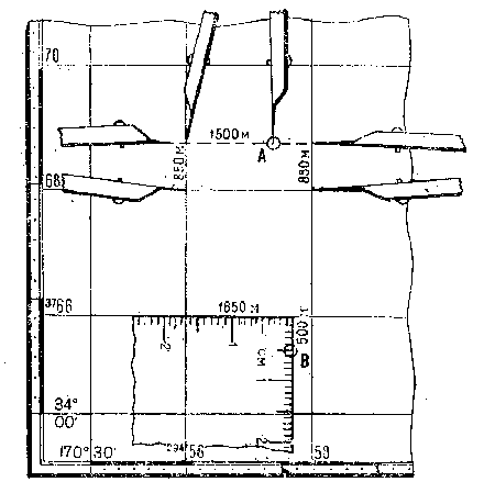
Linear scale- a graphical expression of a numerical scale; it represents a straight line, divided into certain parts, which are accompanied by signatures indicating the distances in the area. The linear scale is used to measure and plot distances on the map. In fig. 10 distance between points BUT and IN equals 1850 m.

Fig. 10. Measuring distances on a linear scale
Transverse scale - a graph (usually on a metal plate) for measuring and plotting distances on a map with extreme graphic accuracy (0.1 mm).
The standard (normal) transverse scale (Fig. II) has large divisions equal to 2 cm, and small divisions (on the left in the graph) equal to 2 mm", in addition, the graph contains segments between the vertical and oblique lines, equal along the first horizontal line - 0.2 mm, on the second - 0.4 mm, on the third - 0.6 mm etc. Using the standard cross-sectional scale, you can measure and plot distances on a map of any (metric) scale. The reading of the distance along the transverse scale consists of the sum of the readings based on the graph and the reading of the segment between the vertical and inclined lines. In fig. 11 distance between points BUT and IN(at a map scale of 1: 100,000) is 5500 m (4 km+1400 m + 100 m).

Fig. eleven. Measuring distances on a transverse scale
Measurement of distances with a compass-meter. At when measuring the distance along a straight line, the needles of the compass are set at the end points, then, without changing the solution of the compass, the distance is measured along a linear or transverse scale. In the case when the compass solution exceeds the length of the linear or transverse scale, the whole number of kilometers is determined by the squares of the coordinate grid, and the remainder is determined by the usual order in scale.
It is convenient to measure broken lines by successively building up the compass solution in rectilinear segments, as shown in Fig. 12.
The measurement of the lengths of the curved lines is carried out by sequential deposition of the "step" of the compass (Fig. 13). The size of the "step" of the compass depends on the degree of tortuosity of the line, but, as a rule, should not exceed 1 cm. To exclude a systematic error, the length of the "step" of the compass, determined by a scale or ruler, should be checked by measuring a line of a kilometer grid with a length of 6-8 cm.
The length of the winding line, measured on the map, is always slightly less than its actual length, since it is not the curved line that is measured, but the chords of the individual sections of this curve; therefore, it is necessary to introduce a correction to the results of measurements on the map — the coefficients of increasing distances (see Table 29).
 Fig. 12. Measuring distances by building up a compass solution
 Fig. 13. Distance measurement with the "step" of the compass
Measuring distances with a curvimeter. By rotating the wheel, the curvimeter arrow is set to zero, and then the wheel is rolled along the measured line with uniform pressure from left to right (or from bottom to top); the resulting reading in centimeters is multiplied by the magnitude of the scale of this map.
Determining distances by rectangular coordinates within one zone can be produced by the formula
where D - line length, l;
Xi, Yi - coordinates of the starting point of the straight line; Xi, yi - the coordinates of the end point of the line.
Determination of areas by squares of a kilometer grid. The area of the plot is determined by counting whole squares and their proportions, assessed by eye. Each square of the kilometer grid corresponds to: on maps with a scale of 1: 25000 and 1: 50,000-1 sq. km, on maps of scale 1: 100,000 - 4 sq. km, on maps of scale 1: 200000-16 sq. km.
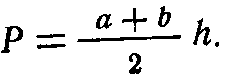
Determination of areas in a geometric way. The site is divided by straight lines into rectangles, triangles and trapezoids. The areas of these figures are calculated using the geometry formulas, having previously measured the required values. Formulas for calculating the area P geometric shapes: - a rectangle with sides A and B:
— right-angled triangle with legs A and B:
— triangle with side o and height h:
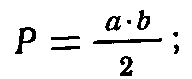

— trapezoid with parallel sides a and & and height h:
1.10. RECTANGULAR COORDINATES ON MAPS
Rectangular coordinates(flat) - linear values: abscissa NS and ordinate Y, determining the position of points on a plane (on a map) relative to two mutually perpendicular axes NS and Y(fig. 14). Abscissa NS and ordinate Y points BUT- distances from the origin to the bases of perpendiculars dropped from a point BUT on the corresponding axes, indicating the sign.

Fig. fourteen. Rectangular coordinates
In topography and geodesy, as well as on topographic maps, orientation is carried out in the north with the counting of angles clockwise, therefore, to preserve the signs of trigonometric functions, the position of the coordinate axes adopted in mathematics is rotated by 90 °.
Rectangular coordinates on topographic maps of the USSR applied by coordinate zones. Coordinate zones are parts of the earth's surface bounded by meridians with a longitude that is a multiple of 6 °. The first zone is limited by the meridians 0 ° and 6 °, the second by 6 ° and 12 °, the third by 12 ° and 18 °, and so on.
The zones are counted from the Greenwich meridian from west to east. The territory of the USSR is located in 29 zones: from the 4th to the 32nd inclusive. The length of each zone from north to south is about 20,000 km. The width of the zone at the equator is about 670 km, at latitude 40 ° - 510 km, t latitude 50 ° -430 km, at latitude 60 ° -340 km.
All topographic maps within a given area have a common rectangular coordinate system. The origin of coordinates in each zone is the intersection point of the middle (axial) meridian of the zone with the equator (Fig. 15), the middle meridian of the zone corresponds to
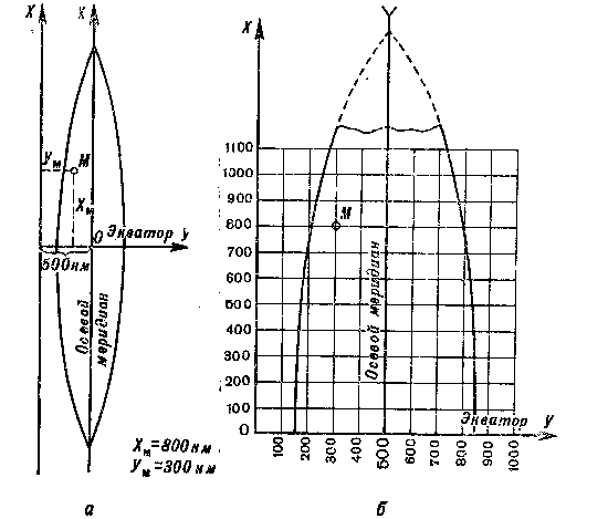
Fig. fifteen. System of rectangular coordinates on topographic maps: a — one zone; b - part of the zone
the abscissa axes, and the equator the ordinate axes. With such an arrangement of the coordinate axes of the abscissa of the points located south of the equator, and the ordinates of the points located to the west of the middle meridian will have negative values. For the convenience of using coordinates on topographic maps, a conditional ordinate count is adopted, excluding negative ordinate values. This is achieved by the fact that the ordinates are counted not from zero, but from the value of 500 km, That is, the origin of coordinates in each zone is, as it were, moved to 500 km left along the axis Y. In addition, to uniquely determine the position of a point along rectangular coordinates on the globe to the coordinate value Y the zone number is assigned to the left (single or two-digit number).
The relationship between conditional coordinates and their actual values is expressed by the formulas:
X "= X-, Y = Y— 500,000,
where X " and Y "- real values of ordinates; X, Y - conditional ordinate values. For example, if the point has coordinates
X = 5 650 450: Y = 3 620 840,
then this means that the point is located in the third zone at a distance of 120 km 840 m from the middle meridian of the zone (620840-500000) and north of the equator at a distance of 5650 km 450 m.
Full coordinates- rectangular coordinates recorded (named) in full, without any abbreviations. In the example above, the full coordinates of the object are given:
NS = 5 650 450; Y = 3620 840.
Abbreviated coordinates are used to accelerate targeting on a topographic map, in this case only tens and units of kilometers and meters are indicated. For example, the abbreviated coordinates of a given object would be:
X = 50 450; Y = 20 840.
Abbreviated coordinates cannot be used for target designation at the junction of coordinate zones and if the area of operations covers an area with a length of more than 100 km in latitude or longitude.
Coordinate (kilometer) grid—A grid of squares on topographic maps, formed by horizontal and vertical lines drawn parallel to the axes of rectangular coordinates at certain intervals (Table 5). These lines are called kilometer lines. The coordinate grid is intended for determining the coordinates of objects and plotting objects on the map by their coordinates, for target designation, map orientation, measurement of directional angles and for approximate determination of distances and areas.
Table 5 Coordinate grids on maps
| Map scales | Sizes of the sides of the squares | Squares of squares, sq. km | |
| on the map, cm | on the ground, km | ||
| 1:25 000 | 4 | 1 | |
| 1:50 000 | 2 | 1 | 1 |
| 1:100 000 | 2 | 2 | 4 |
| 1:200 000 | 2 | 4 | 16 |
On a map with a scale of 1: 500,000, the coordinate grid is not shown in full; only the outputs of the kilometer lines on the sides of the frame are applied (after 2 cm). If necessary, a grid can be drawn on the map for these outputs.
Kilometer lines on maps are signed at their outside exits and at several intersections within the sheet (Fig. 16). The kilometer lines extreme on a sheet of the map are signed in full, the rest - in abbreviated form, in two numbers (that is, only tens and units of kilometers are indicated). The labels on the horizontal lines correspond to the distances from the ordinate (equator) in kilometers. For example, the signature 6082 in the upper right corner shows that this line is located at a distance of 6082 from the equator km.
Vertical line labels indicate the zone number (one or two first digits) and the distance in kilometers (always three digits) from the origin, conventionally shifted west of the middle meridian by 500 km. For example, the signature 4308 in the lower left corner means: 4 - zone number, 308 - distance from the conventional origin in kilometers.
An additional coordinate (kilometer) grid can be drawn on topographic maps at a scale of 1: 25,000, 1: 50,000, 1: 100,000 and 1: 200,000 at the outputs of kilometer lines in the adjacent western or eastern zone. Outputs of kilometer lines in the form of dashes with corresponding signatures are given on maps located 2 ° east and west of the boundary meridians of the zone.
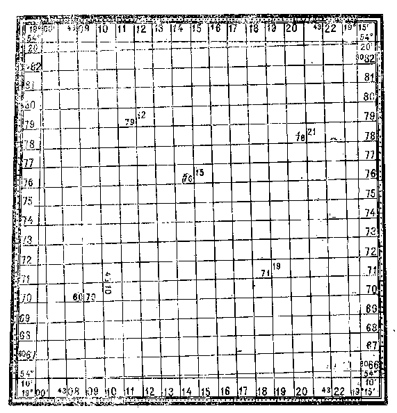 Fig. sixteen. Coordinate (kilometer) grid on a map sheet
An additional coordinate grid is used to transform the coordinates of one zone into the coordinate system of another, neighboring, zone.
In fig. 17 dashes on the outside of the western frame with captions 81.6082 and on the north side of the frame with captions 3693, 94, 95, etc. denote the outputs of the kilometer lines in the coordinate system of the adjacent (third) zone. If necessary, an additional coordinate grid is drawn on the map sheet by connecting lines of the same name on opposite sides of the frame. The newly constructed grid is a continuation of the kilometer grid of the map sheet of the adjacent zone and must completely coincide (merge) with it when gluing the map.

The coordinate grid of the western (3rd) zone
Fig. 17. Additional coordinate grid
1.11. DETERMINATION OF RECTANGULAR COORDINATES ON THE MAP AND APPLICATION OF OBJECTS ON THE MAP BY COORDINATES
Determination of the rectangular coordinates of the object on the map with a compass. A compass is used to measure the perpendicular distance from the given object to the lower kilometer line, and its actual value is determined from the scale. Then this value in meters is attributed to the right to the signature of the kilometer line, and when the length of the segment is more than a kilometer, the kilometers are first summed up, and then the number of meters is also attributed to the right. This will be the coordinate of the object NS(abscissa).
The same method is used to determine the coordinate Y(ordinate), only the distance from the object is measured to the left side of the square, In the absence of a compass, distances are measured with a ruler or a strip of paper

Fig. 18. Determination of rectangular coordinates of objects on the map
An example of determining the coordinates of an object BUT shown in fig. eighteen:
X = 5,877100; Y == 3,302,700.
X = 5 874 850; Y = 3 298 800.
Determination of rectangular coordinates by the coordinate meter. Coordinate-dinatomer is a device for reading coordinates. The most common coordinate atomic meter is in the form of a right angle of a transparent ruler, on the sides of which there are millimeter divisions. This type of coordinator is available on the command line.
When determining the coordinates, the coordinate gauge is superimposed on the square in which the object is located and, aligning the vertical scale with its left side, and the horizontal scale with the object, as shown in Fig. 18, the readings are taken.
Readings in millimeters (tenths of a millimeter are counted by eye) in accordance with the scale of the map are converted into real values - kilometers and meters, and then the value obtained on the vertical scale is summed (if it is more than a kilometer) with digitizing the lower side of the square or attributed to it on the right (if the value is less than a kilometer). This will be the coordinate NS object.
The coordinate is obtained in the same order Y - the value corresponding to the reading on the horizontal scale, only the summation is carried out with the digitization of the left side of the square.
In fig. 18 shows an example of determining the rectangular coordinates of object C: X - = 5,873,300; Y = 3 300 800.
Drawing an object on the map along rectangular coordinates with a compass or ruler. First of all, according to the coordinates of the object in kilometers and the digitization of kilometer lines, a square is found on the map, in which the object should be located.
The square of the location of the object on a map of scale 1:50 000, where kilometer lines are drawn after 1 km, found directly by the coordinates of the object in kilometers.
On a 1: 100,000 scale map, kilometer lines are drawn in 2 km and are signed with even numbers, so if one or two coordinates of an object in kilometers are odd numbers, then you need to find a square whose sides are signed with numbers one less than the corresponding coordinate in kilometers.
On a 1: 200,000 scale map, kilometer lines are drawn after 4 km, therefore, the sides of the required square will be labeled with numbers that are multiples of four, less than the corresponding coordinate of the object in kilometers by one, two or three kilometers. For example, if the coordinates of the object (in kilometers) are given: X == 6755 and Y = 4613, then the sides of the square will have digitization: 6752 and 4612. After finding the square in which the object is located, the distance of the object from the lower side of the square is calculated and laid off on the map scale from the bottom corners of the square up. A ruler is laid to the obtained points and from the left side of the square, also in the scale of the map, a distance equal to the distance of the object from this side is plotted.
 In fig. 19 shows an example of object mapping BUT by coordinates: X = 3 768 850, Y = 29 457 500.
Fig. nineteen. Drawing objects on the map by rectangular coordinates
Drawing an object on the map with a coordinate meter, engraved on the commander's ruler. The coordinates of the object in kilometers and the digitization of kilometer lines determine the square in which the object is located. A coordinate meter is superimposed on this square in the same way as when determining coordinates (see Fig. 18), its vertical scale is aligned with the western side of the square so that against the bottom side of the square there is a reading corresponding to the coordinate NS to the map scale minus the digitization of that side of the square. Then, without changing the position of the coordinate meter, a reading is found on the horizontal scale corresponding (also in the scale of the map) to the reality of the coordinate Y object and digitizing the western side of the square. The point against the dash at this reference will correspond to the position of the object on the map.
In fig. 19 shows an example of mapping object B, located in an incomplete square, according to coordinates:
NS = 3,765,500; Have = 29 45750.
In this case, the coordinate gauge is superimposed so that its horizontal scale is aligned with the north side of the square, and the counting against its west side corresponds to the coordinate difference Y object and digitization of this side (29457 km 650 m— 29456 km = 1 km 650 m). The count corresponding to the difference between the digitization of the north side of the square and the coordinate Y object (3766 km - 3765 km 500 m), put down on a vertical scale. Dot versus dash at count 500 m will indicate the position of the object on the map.
1.12. GEOGRAPHICAL COORDINATES AND DETERMINING THEM ON THE MAP
Geographical coordinates- angular values: latitude (p and longitude TO, determining the position of objects on the earth's surface and on the map (Fig. 20).
Latitude - the angle (p between the plumb line at a given point and the plane of the equator. Latitudes vary from 0 to 90 °; in the northern hemisphere they are called northern, in the southern - southern.
Longitude - dihedral angle TO between the plane of the prime meridian and the plane of the meridian of a given point on the earth's surface. The prime meridian is the meridian passing through the center of the Greenwich Observatory (London area). The prime meridian is called Greenwich. Longitudes range from 0 to 180 °. Longitudes measured east of the Greenwich meridian are called east, and longitudes,. counted to the west - by the west.
Geographic coordinates obtained from astronomical observations are called astronomical, and coordinates obtained by geodetic methods and determined from topographic maps are called geodetic ones. The values of astronomical and geodetic coordinates of the same points differ insignificantly - in linear measures on average by 60-90 m.
Geographic (cartographic) grid formed on the map by lines of parallels and meridians. It is used for targeting and determining the geographic coordinates of objects.
On topographic maps, the lines of parallels and meridians serve as the inner frames of the sheets; their latitudes and longitudes are inscribed at the corners of each sheet. On the map sheets for the Western Hemisphere, in the northwest corner of the frame, the inscription "West of Greenwich" is placed.

Fig. twenty. Geographic coordinates: f — latitude of point L; TO- point longitude BUT
On sheets of maps of scale 1: 50000, 1: 100000 and 1: 200000, the intersections of the mean parallels and meridians are shown and their digitization is given in degrees and minutes. From these data, the signatures of the latitudes and longitudes of the sides of the frames of the sheets, cut off when gluing the map, are restored. In addition, along the sides of the frames inside the sheet, small (2-3 mm) strokes in one minute, along which you can draw parallels and meridians on a map glued from many sheets.
On maps with a scale of 1: 25,000, 1: 50,000 and 1: 200,000, the sides of the frames are divided into segments equal in degree to one minute. Minute segments are shaded by one and divided by dots (except for a map with a scale of 1: 200000) into parts of 10 ".
On the map sheets of 1: 500,000 scale, the parallels are drawn through 30 ", and the meridians - through 20"; on maps of scale 1: 1,000,000
parallels are drawn through 1 °, meridians - through 40 ". Inside each sheet of the map, on the lines of parallels and meridians, their latitudes and longitudes are signed, which make it possible to determine geographic coordinates on a large gluing of maps.
Definition geographic coordinates of the object the map is made according to the parallels and meridians closest to it, the latitude and longitude of which are known. On maps with a scale of 1: 25000—
 1: 200,000 for this it is necessary, as a rule, to first draw a parallel south of the object and a meridian to the west, connecting the corresponding strokes along the frame of the map sheet with lines. The latitude of the parallel and the longitude of the meridian are calculated and signed on the map (in degrees and minutes). Then the segments from the object to the parallel and the meridian are evaluated in angular measure (in seconds or fractions of a minute). (Ami and Ami in fig. 21), comparing their linear dimensions with minute (second) intervals on the sides of the frame. The size of the segment ATi add to the latitude of the parallel, and the segment Ami - to the longitude of the meridian and get the desired geographical coordinates of the object - latitude and longitude.
In fig. 21 shows an example of determining the geographic coordinates of an object BUT, its coordinates: north latitude 54 ° 35 "40", east longitude 37 ° 41 "30".
Drawing an object on a map using geographic coordinates. On the western and eastern sides of the frame of the map sheet, the readings corresponding to the latitude of the object are marked with dashes. The latitude counting starts from digitizing the southern side of the frame and continues in minute and second intervals. Then a line is drawn through these lines — the parallel of the object.
The meridian of the object is built in the same way, only its longitude is measured along the southern and northern sides of the frame. The point of intersection of the parallel and the meridian will indicate the position of the object on the map.
In fig. 21 is an example of mapping an object IN coordinates: d = 54 ° 38 ", 3; w = 37 ° 34", 7.
1.13. POLAR AND BIPOLAR COORDINATES
Polar coordinates- quantities that determine the position of a point on the plane relative to the starting point taken as a pole. These values are the angle of position, measured from the direction of the polar axis, and the distance (range) from the pole to the point to be determined (Fig. 22).

Fig. 22. Polar coordinates: position angle, a and distance (range) D
The polar axis can be a direction to a landmark, a meridian line (true or magnetic), or a vertical grid line. The angles of position from the true meridian, magnetic meridian and vertical grid line are called true azimuths, magnetic azimuths and directional angles, respectively (see section 1.14) and are counted clockwise.
Polar coordinates are widely used in orientation and target designation.
Bipolar coordinates — two linear or angular quantities that define the position of a point relative to two original points (poles). The linear quantities are the distances (ranges) from the poles to the point to be determined. Angular quantities can be magnetic or true azimuths, directional angles or angles measured from a line connecting the original points (Fig. 23).
Rapprochement of meridians - angle f(Fig. 24) between the north direction of the true meridian of this point and the vertical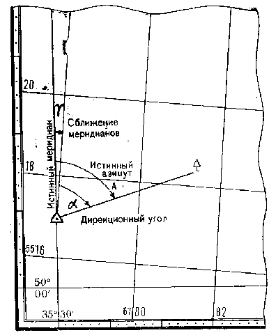
Fig. 24. Direction and convergence of meridians
a grid line (or a line parallel to it). The convergence of the meridians is measured from the north direction of the true meridian to the north direction of the vertical line. For points located to the east of the middle meridian of the zone, the magnitude of the approach is positive, and points located to the west - negative,
The magnitude of the convergence of the meridians on the axial meridian of the zone is equal to zero and increases with distance from the middle meridian of the zone and from the equator; its maximum value will be near the poles and does not exceed 3 °.
The convergence of meridians, indicated on topographic maps, refers to the middle (central) point of the sheet; its value within a sheet of a map of scale 1 :1
The declination of the magnetic needle to the east is considered to be east (positive), and to the west - west (negative). Transfer from directional the angle to the magnetic azimuth to the back is produced different ways; all the necessary data for this is available on each sheet of the map at a scale of 1:25 000— 1: 200,000 in a special text help and a graphic diagram, placed in the margins of the sheet in the lower left corner (Fig. 25). Go through the direction correction. In the text help placed on the maps, the value (in degrees and divisions of the goniometer) and the sign of the correction for the transition from the directional angle to the magnetic azimuth are indicated. For example, in the help shown in fig. 25, it is indicated: "Correction to the directional angle in the transition to the magnetic azimuth plus (0-16)". Therefore, if the directional angle of the direction is 18-00 div. ang., then the magnetic azimuth will be equal to 18-16 div. ang. In the reverse transition, that is, when determining the directional angle by the magnetic azimuth, the sign of the correction is reversed and it is introduced into the magnetic azimuth. For example, if the magnetic azimuth is 10-00, then the directional angle of this direction for this map (Fig. 25) is 9-84 (10-00-0-16). Transitional graphic diagram (Fig. 26). The diagram shows the approximate direction to the object and, in accordance with the position of the vertical line of the coordinate grid and the line of the magnetic meridian, increase or decrease the initial angle by the correction indicated in the diagram in brackets. An example of the transition from a directional angle equal to 120 ° 30 "to the magnetic azimuth of this direction in 1972 (the initial data are taken from Fig. 25). 1. Determination of the magnitude of the change in the declination of the magnetic needle for 7 years (1972-1965): D = 0 ° 05 ", 2X7 = 0 ° 36". 2. Calculation of the declination of the magnetic needle for 1972: b = -3 ° 10 "+ 0 ° 36" = - 2 ° 34 ". 3. Transition from the directional angle to the magnetic "azimuth according to the basic formula (see above) A m = 120 ° 3 (Y— (—2 ° 34 ") + (—2 ° 12") =
120 ° 52 ". 1.15. MEASURING DIRECTIONAL ANGLES ON THE MAP Measurement with a protractor. With a finely sharpened pencil, neatly along a ruler, draw a line through the main points of the conventional signs of the starting point and reference point. The length of the drawn line must be greater than the radius of the protractor, counting from the point of intersection with the vertical line of the graticule. Then the center of the protractor is aligned with the intersection point and rotated in accordance with the angle, as shown in Fig. 27. Reading against the drawn line at the position of the protractor indicated in fig. 27, a, will correspond to the value of the directional angle, and with the position of the protractor indicated in Fig. 27.6, 180 ° must be added to the reading obtained. When measuring the directional angle, it must be remembered that the directional angle is measured from the north direction of the vertical grid line clockwise. The average error in measuring the directional angle with a protractor on the commander's ruler is approximately 1 °. A large protractor (with a radius of 8-10 cm) the angle on the map can be measured with an average error of 15 ". Fig. 27. Measuring directional angles with a protractor Measurement with a chordouglometer(fig. 28). Through the main points of the conventional signs of the starting point and landmark, draw a thin straight line on the map with a length of at least 12 cm. From the point of intersection of this line with the vertical line of the grid of the map, markings are made on them with a compass with a radius equal to the distance on a chordouglo-measure from 0 to 10 large divisions. Serifs are made on lines forming an acute angle. Then the chord is measured - the distance between the marks of the deferred radii. To do this, the left needle of the caliper with a deferred chord is moved along the extreme left vertical line of the chordouglometer scale until the right needle of the compass coincides with any intersection of the inclined and horizontal lines. In this case, the right needle must be moved strictly at the same level with the left. In this position, the compass is counted against its right needle. Large and tens of small divisions are counted along the upper part of the scale. On the left side of the scale with a division value of 0-01, the value of the angle is specified. An example of measuring an angle with a chordouglometer is shown in the figure. Using a chordouglometer, an acute angle is measured from the nearest vertical line of the coordinate grid, and the directional angle is counted from the north direction of the grid line clockwise. The value of the directional angle is determined by the measured angle, depending on the quarter in which the landmark is located. Relationship between measured angle but" and the directional angle a is shown in Fig. 29. The angles with a chordouglometer can be measured with an average error of 0-01—0-02 divs. ang. (4-8 "). Fig. 29. The transition from the angle a ", measured by the chordouglometer, to the directional angle a Artillery circle measurement. The center of the circle is aligned with the starting point (the main point of the conventional sign) and the circle is set so that its diameter 0-30 is parallel to the vertical lines of the coordinate grid, and zero is directed to the north. Then the scale bar is aligned with the main point of the reference mark and the angle value is read at the intersection of the edge of the ruler with the scale of the circle. Artillery circle can measure the directional angle without a scale ruler (Fig. 30). In this case, a line is preliminarily drawn on the map through the main points of the conventional signs of the starting point and landmark. Then the artillery circle is set, as indicated above, and the direction angle is read against the drawn line on the scale of the circle. Directional angle with artillery circle. can be measured with an average error of 0-03 divs. ang. 1.16. BUILDING ON MAP DIRECTIONS Plotting directions on a directional angle in a degree measure is done with a protractor. Draws a line parallel to the vertical line of the coordinate grid through the main point of the reference point of the starting point. A protractor is applied to it, as shown in Fig. 27. Against the corresponding division of the protractor scale, a mark is made on the map and then, having removed the protractor, connect it with a straight line with the starting point. This line will correspond to the given direction. An artillery circle is used to plot the directions on the map at the direction angles in the divisions of the goniometer. The center of the circle is aligned with the starting point and the circle is set with a diameter of 0-30 parallel to the vertical grid lines with zero division to the north. On a scale with signatures increasing clockwise, against the required division, a mark is made on the map. A straight line drawn through the origin and this elevation will be the desired direction.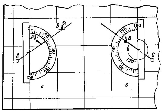
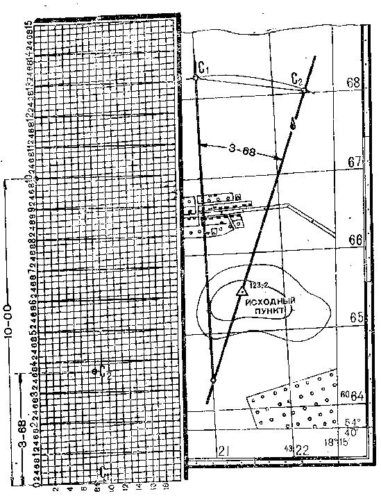 Fig. 28. Measurement of the directional angle with a chordouglometer
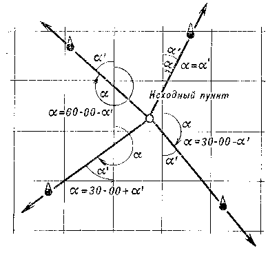
 Fig. thirty. Measuring the directional angle with an artillery circle