What are the old cards. Old maps online
Retromap Old cards. The site is just great.
Collected all sorts of old maps.
You can find maps by city, or you can click Map selection and get an explorer, as in a computer with folders and subfolders.
We select the required tree from the list and get:
You can visually pick up the card. The base is incredible. When we select a card, we get to interactive map like Google or Yandex.
However, why "like Google or Yandex"? - There are both Google and Yandex. Also have bing map, Wiki and OpenStreetMaps and photos from Google satellite maps. That is, you can see the old map, and then jump to Yandex and immediately see how the map looks today.
And you can make 2 windows and watch in parallel.
You can choose cards by year. Just keep in mind, here old cards are tied to modern ones. interactive services maps, but they do not cover the whole earth. Each card has its own area.
Some cards cover more space and some less.
Some resolution is higher, some lower. Let's be forgiving and understanding.
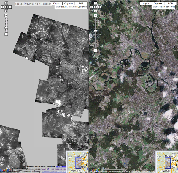
http:// warfly.com
Aerial photographs of the cities of the USSR, made during the war.
There are dozens of cities on the list. The images are superimposed on Google maps.
To compare photos of the city of those years with modern satellite photos, select full screen mode and click on the "2 in 1" link.
![]() https://
https://
One-verst maps of the territories of modern Belarus, Lithuania, Poland, Latvia and Russia.
Free registration is required. On the site, you can watch vintage cards in parallel (up to 4 windows) with google maps or Yandex.
There is a search and the ability to download maps.

![]() https://www. oldmapsonline.org
https://www. oldmapsonline.org
Search for ancient maps from the British Museum archive using Google maps.
- We choose the time on a scale of 1000-2010,
- indicate a place on the map on the map, or set the overgrowth of a geographical point in the search form,
- in the right panel we will see previews of available maps according to our request.
- choose desired card and get into a window with a description and a link to the archive, where you can find and buy this card.

![]() http://www. etomesto.ru
http://www. etomesto.ru
Parallel viewing of old and modern maps online.
The site primarily presents old maps of Moscow and the Moscow region, St. Petersburg and Leningrad region, a number of regions of Russia, there is something in Ukraine, Belarus, Moldova, Kazakhstan, the Baltic countries and the Caucasus. Here you can not only study in detail the historical heritage of Russian, Soviet and foreign cartography, but also apply the information received for practical purposes. So, with the help of the site, you can find out the history of your small Motherland or all of Russia on maps of different times. What used to be on the site of your house, what names did settlements and streets have in ancient times, where you should not buy an apartment - if the house was built on a former landfill or churchyard, where the former village of your ancestors was, where it is worth walking around with a metal detector in search of treasure, where search teams can look for the unburied remains of our soldiers from the times of the Great Patriotic War - our project will help answer these and many other questions. Our search base geographical objects contains not only names settlements, but also the location of tracts, relief objects, old names from the times of the USSR, places of abandoned villages. The selected piece of any map can be printed, saved as a picture with an overlaid pointer, exported to Google Planet Land for viewing in 3D, embed in your blog or on your local history website. If you are interested in something on the plan, then you can download the waypoint with one click WPT or GPX for GPS navigator or tag kml with the coordinates of this place. Almost any online map You can download it to your computer from the server and use it offline. Maps are laid out in image and PDF formats, as well as files for navigation programs working with raster maps: OziExplorer, OruxMaps, Androzic, Locus Map, Locus Pro, AlpineQuest, Galileo Offline Maps, etc.

ancient globe
http:// dinosaurpictures.orgEnglish language
What the earth looked like many, many years ago. On a globe site, like on Google maps, you can set the time in millions of years and see how the continents looked. Of course, everything was very, very approximately the same, because then cartography did not exist and scientists guess with a high degree of probability by time and place. So the site just gives a general impression. You can set, for example, your address and see what was there before.
I think there is no need to tell how important cards are in finding coins and treasures. The success of most events depends on their presence or absence. If in the old days it was enough simple desire get out into the fields, now the situation has changed radically. All more or less well-known tracts, and what's there, even completely lost in the forests and steppes, turned out to be quite thoroughly cleaned for ancient finds.
To keep adding to your collection, or just to enjoy the cop, you have to show more and more remarkable abilities in the field of finding untrodden places. In this case, the most important role is played by the cards of bygone centuries.
Currently, many of them are available to anyone, but as the advertisement says, they are not all equally useful. Yes, this is true, most of them are only suitable for planning trips to broken places.
Below we will describe what cards are, reveal their features and characterize them in terms of usefulness in business.
General Land Survey Plan - PGM (1780-1830)
Topographic materials began to be actively created under Peter I, at which time a large number of geographical atlases of the empire saw the light. During the reign of Catherine II, these works were continued. They, like Peter's, also did not differ in particular accuracy, but, nevertheless, they nevertheless transmitted the necessary and necessary information.
It was under Catherine the Great that the process of mass land surveying began. Its essence was as follows - the entire territory of the country was divided into counties, which, in turn, consisted of the so-called dacha plans, which were nothing more than plots of owners (allots) with confirmed rights to them and established boundaries. All of them received numbers, for their decoding, an additional Economic note was later issued to the survey plans.
These publications can hardly be called maps, because. they are still far from accurate and are more like diagrams-drawings. But still, you can get a lot of them. useful information on the emergence or existence of a particular settlement in those days.
Maps of Mende (1849-1866)
The name of these, and subsequently many other maps, was given by the names of the people who made the greatest contribution to their development and creation. All of them relied on and had the basis of publications created under Catherine and Paul I, it was on these initiatives that the further development of the so necessary was carried out, in primarily military, modern maps.
The new realities of that time revealed the need to create more accurate and detailed maps than the existing Military Road 40-verst editions. Taking the PGM as a basis and conducting large-scale cartographic surveys, military topographers under the leadership of A.I. Mende set about creating new detailed editions.

In total, two varieties of them were released.:
- one-verst, scale 1 inch is equal to 1 verst or 1cm is equal to 420m
- two-verst, scale in 1 inch 2 versts or 1cm 840m.
Such detailed publications appeared in 8 provinces, although surveys of the area were carried out in 21 provinces for 17 years.
provinces
1 and 2 versts - Tver, Vladimir, Ryazan, Penza, Simbirsk and Tambov.
1 verst - Nizhny Novgorod and Penza.
Schubert Maps (1860-1870)
Under the leadership of F.F. Schubert, who headed the Corps of Military Topographers at the beginning of the 19th century, a 10-verst map of the Western part of Russian Empire on 60 sheets. But it, like the border 4 and 5 verst, was not very convenient, so soon work began on another.
A new map - three versts was created first under the leadership of Major General P. A. Tuchkov (until 1851), and then work continued with the participation of Schubert. The period of its creation covers the second half of the 19th century, starting from 1846.
The scale is 3 versts in 1 inch or 1260 m in 1 cm.

The main part of the work was done before 1863 (435 sheets), further work was not suspended (in 1886 - 508 sheets), but basically it was reduced to supplementing and clarifying previous editions.
They turned out to contain cartographic material for all the provinces of the European part of the empire (with the exception of Moscow) and part of the adjacent territories (Ukraine, Belarus, Moldova and the Baltic states).
This map is distinguished by good detailing with displaying the type of relief and the nature of the terrain: forest, swamp, rivers and streams, bridges, crossings, etc. All significant objects are placed on it, ranging from schemes of cities to villages with an indication of the number of courtyards, churches, mills, field and forest roads.
When using these materials, it is worth remembering two important features:
1) The accuracy of the designation of various objects has some error, for example, for the most significant it can be from 50 to 200m, for others - from 100 to 500m, and sometimes more.
2) When designating villages, it was customary to subdivide them by size using font, the names of large villages (20 or more households) were written in normal font, small villages and farms in italics.
Strelbitsky Maps
Starting from 1865, I.A. Strelbitsky, who at that time was part of the military topographic department at the General Staff, was instructed to update and supplement the Special Map of the European part of Russia. Under his leadership, work continued from 1865 to 1871. The publication consisted of 178 sheets, covered the provinces located in the center of the country, as well as parts of the adjacent western and southern territories.

Scale: 10 versts in 1 inch or 4200m in 1 cm.
In the future, it was she who served as the basis for the creation of such publications until the middle of the 20th century.
Red Army
These cards bear the abbreviated name of the Workers 'and Peasants' Red Army. These works have been published since the 1920s. Of course, for the most part they were based on publications issued before the revolution of 1917 (mostly layouts were used) and covered primarily the Western regions of the country. They were printed in the period from 1925 to 1941. The scale is from 250m to 5km.

They were produced with a number of additions and improvements, so they were actively used during the Second World War.
These maps are characterized by very clear detail and detail, they display all roads, including the smallest ones, settlements with an indication of the number of yards, and other objects of interest from the point of view of military tactics. The vast majority of the sheets are made in color, but there are also black and white versions.
Their usefulness is certainly high, in view of the fact that many villages disappeared immediately or some time after the end of the war.
General Staff
From the name it is clear that they were produced for military needs, although they were also used by other services, for example, geodetic, topographic, geological, etc. These include editions released after the Second World War, which are again improved and modified previous maps. All of them have the same shape - the territory is divided into sheets, each of them, in turn, is divided into squares.
Initially, they were considered secret and it was almost impossible to get them in Soviet times. Now many (not all) of them are available for use.
Taking into account the fact that the General Staff has a much smaller error with respect to the coordinate grid, it makes sense to use them (in the absence of old ones) to search for tracts and plan travel routes.

The scale of such maps is the most diverse, ranging from 500 meters to 10 kilometers.
In addition to the above maps, of course, there are many other interesting ones. For example, in the 19th century, many provinces published their own - vicegerent maps, and many search engines also enjoyed great success with German (KDWR), Polish (WIG), which in fact are redrawn Russian layouts.
All maps can be used literally, so to speak, but if at least something can be found on the Soviet General Staff (at least the villages that existed after the war), then it is much more difficult to do this on versts, they require reference to the terrain. This is done using special programs, and then the already processed materials are loaded into the navigator.
Surveys of the area made tens and even hundreds of years ago are the history of our country. They will provide invaluable assistance not only to amateurs, but also to those who simply love to travel, study their land, its origin and development, and simply those who simply want to know the origin of their kind.
What could be more interesting than search new places to cop? Probably the search process itself with a metal detector. After all, if you look, all search engines can be divided into several categories. Someone has bought a metal detector for fun and goes out in search only occasionally, while the person is not ready to invest and spend money on this hobby.
Such people rarely give themselves completely to this hobby, respectively, and the search for places for them is limited either to the territory that is adjacent to the house (if we are talking about villagers), or they visit the fields closest to the metropolis. As a rule, this category of citizens in rare cases is selected for a cop for a hundred or two kilometers. And this is normal, because for them a cop is just a one-time adventure out of a thousand possible, to each his own.

Another category of search engines are people who are inspired by this type of hobby, but for whom it is not the main one or there are some restrictions in order to fully devote themselves to the search business. For example, a person has a lack of time, he does not have a car, a person is passionate about some other hobby that is suppressed by treasure hunting (tourism, hunting, fishing, and so on). People from this group devote much more time to searching, sometimes even studying old maps, but still for them the priority is the main hobby, and treasure hunting is in the background and searching with a metal detector is a nice addition.

True treasure hunters
And, finally, the third group of people are true treasure hunters who have gone headlong into the search. For such people, searching is a hobby, adrenaline, emotions, they are completely distracted and abstracted from pressing problems when they are engaged in treasure hunting. We can say that they live it, morally. Accordingly, winter for them is a time to take stock of the outgoing season, well, to find new places, to make a plan for the next season.

We have already talked about the search for new places, and various programs that allow you to look at the world from space are of great help. But, in addition to the satellite, old maps are also very useful, which can give the search engine a lot of information. For example, on numerous forums, many treasure hunters write about how to use old cards, how to overlay them on new ones, how to make a binding, and so on. I use these methods, but having been doing treasure hunting for more than one year, I have developed my own strategy for finding new places.

For example, one of the search engines seeks to find a disappeared village. And it's good if you can find it. But, as a rule, such villages have already been passed by search engines and treasure hunters more than once. And although there are no knocked-out places, you need to know this rule, and it really works, but it’s much more pleasant to look where the field is flat and you can’t see the pits of comrades. So, in addition to the previously existing villages on old maps, I am looking for those that still exist. There are much more such settlements than plowed villages, therefore, you can safely go searching in the vicinity of such a village.

Experience shows that if you find a village that is at least 100-150 years old, then by drawing a circle around it with a radius of 1500-2000 meters, you can continue to search in this place for more than one year. Places near rivers are lucky, especially where there used to be mills. This information can be obtained from old maps. It is difficult to find the exact place, but there is a trick here. As a rule, rivers keep their course for 100-200 years. Therefore, with some degree of probability, it is possible to combine the map with satellite image oriented along the riverbed. Well, then - a matter of technology.

We found an approximate point, hammer it into the navigator, and already look around on the ground. Accuracy, in this case, may vary, and sometimes you first need to walk on the spot without a metal detector, walk 1-3 kilometers along the coast in both directions. But, a number of signs will unequivocally indicate that once there could be a mill here: a convenient coast, a good approach, whirlpools, old roads, and so on. Well, do not forget to talk to the locals, who can tell you something about the place.

Using forums for treasure hunting
You can search for places and reading forums. Some of the comrades can boast of finds, and if you recognize the place (or the members of the forum wrote it yourself, or you somehow recognized the place from photographs), then access to the areas bordering this place may be quite successful. For example, there was a case when one of the search engines I knew found one swag field, we were very good at one time. But everything comes to an end sometime.

So, the maps said that there was nothing more to do here, but we decided to explore the adjacent interesting field forest, go through a section of 1300 meters, delving into the forest no more than 100-150 meters. The site is huge, and it is clear that it is not one day to go through it all. But we periodically went there, and slowly led with metal detectors. The calculation was simple: if the field is so dirty, people used to plant something there, then these same people could enter the adjacent forest, rest or hide something, they could lose something. As a result, there were coins, buttons, and other interesting finds.

As you can see, there are many ways to search for places to search, and each treasure hunter develops his own search scheme over the years. And looking at maps in winter (the most different cards at different scales), you can discover a lot. By the way, do not forget to mark in your navigator the most interesting points where you had finds. When there are more than a dozen of these points, you can “draw” an interesting map of your own, which will “open” your eyes to many things. And what are your secrets for choosing a place for a cop?
Your Alexander Maksimchuk!
Best Award for me as an author - your like in social media(tell your friends about this article), also subscribe to my new articles (just enter your email address in the form below and you will be the first to read them)! Do not forget to comment on the materials, and also ask any questions you have about treasure hunting! I am always open to communication and try to answer all your questions, requests and comments! Feedback on our site works stably - do not be shy!
is not just a piece of art, but also a source of important historical information of considerable value. That is why many historians, local historians, treasure hunters and others are looking for rare old maps and are ready to buy them for more money. Demand creates supply: the number of Internet sites that give rights to download old cards for payment is growing every day.
Our site is not one of those. You can download all the old maps of provinces and districts of Russia presented on our website for free. All old maps can be downloaded either directly from the pages of our site or from the "People" service. Narod is a Yandex service for storing files.
The Russian Empire (other names: All-Russian Empire, Russian State or Russia) was proclaimed following the results of the Northern War (1700-1721) by the Russian Tsar Peter I the Great and lasted until the collapse of the monarchy in 1917.
The capital of the Russian Empire was first St. Petersburg from 1721 to 1728, then Moscow (1728-1730), and then again St. Petersburg (in 1914 the city was renamed Petrograd) in 1730-1917.
By the end of the 19th century, the Russian Empire occupied 1/6 of the land and extended to the Arctic Ocean in the north and the Black Sea in the south, to the Baltic Sea in the west and the Pacific Ocean in the east.
On our website you can download for free the following old maps of the Russian Empire:
- Atlas of Russia, 1745
- A new map of the Russian Empire, divided into governorships, 1786
- Atlas of the Russian Empire, 1792
- Atlas of the Russian Empire, consisting of 52 maps, 1796
- Pocket Postal Atlas of the Russian Empire, 1808
- Geographical Atlas of the Russian Empire, 1820-1827
- Atlas of the Russian Empire, 1843
- , 1871
- Maps of Russia from The Comprehensive Atlas & Geography of The World, 1882
- Maps of the Russian Empire from Reference Atlas of the World, 1887
- Maps of the Russian Empire from Harmsworth Atlas and Gazetteer, 1909
- Map of Communications of the Russian Empire, 1916
Free download old maps of the European part of Russia
European Russia is the most populated and most developed part of the country located in Europe. natural borders European Russia from the Asian served the Ural Range, r. Ural, Caspian Sea and Caucasus Range.
On our site you can download the following old maps of the European part of Russia for free:
- General Land Survey Plans (PGM), 1766-1861
- , 1799
- Postal map of European Russia, 1871
- Military topographic map of the western part of the Russian Empire (three-verst).
- Schubert's map (Special map of the Western part of the Russian Empire), 1826-1840
- Strelbitsky Map (Special Map of European Russia).
- Marx's Large World Desktop Atlas (Map of European Russia), 1909
- Large scale map of Russia in Europe, 1918
Free download old maps of Asiatic Russia
Asian Russia is a part of the Russian Empire located on the Asian continent. According to the Brockhaus and Efron encyclopedia, Asiatic Russia includes Siberia, Central Asian possessions and the Caucasus region. The natural borders of Asian Russia from European Russia were the Ural Range, the river. Ural, Caspian Sea and Caucasus Range. Asian Russia occupied the entire northern part of Asia.
On our site you can download for free the following old maps of Asiatic Russia:
- General map of Western Siberia with the Kirghiz steppe, 1848
- Map of Asian Russia, 1868
- Postal map of Asian Russia, Siberia, 1871
- Map of Asiatic Russia with possessions adjacent to it, 1884
- Road map along the rivers of Western Siberia: Ture, Tobol, Irtysh, Ob and Tom, 1884
- Map of the lines of communication of Asiatic Russia, 1901
- Atlas of Asian Russia, 1914
Free download old maps of individual provinces and regions
Province, the highest unit of administrative division and local structure in Russia, which took shape in the 18th century. For the first time, the division of the Russian Empire into provinces was carried out in 1708-1715 by Tsar Peter I by decree on regional reform. In 1708, the country was divided into 8 provinces headed by governors, endowed with full judicial and administrative power. Later, Empress Catherine II carried out a public administration reform, during which Russia was divided into 50 provinces headed by governors.
By 1914, Russia was divided into 78 provinces, 21 regions and 2 independent districts, in which there were 931 cities, and the Russian Empire included the Baltic states, Little Russia, Belarus, part of Poland (the Kingdom of Poland), Bessarabia, the North Caucasus, from the 19th century, in addition, Finland (Grand Duchy of Finland), Transcaucasia, Kazakhstan, Central Asia, etc.
On our website you can download the following old maps of provinces and districts of the Russian Empire for free:
Download old maps of St. Petersburg province
- Topographic map of the environs of Saint Petersburg, 1831
- Topographic map of Saint Petersburg Governorate, 1834
- Topographic map of parts of St. Petersburg and Vyborg provinces, 1860
- Map of the Petrograd Governorate, 1916
Download old maps of the Moscow province:
- Topographic map of Moscow Governorate, 1860
- Map of the outskirts of Moscow, 1878
Download old maps of the Crimean peninsula: